
FIELD GUIDE · CHAPTER 12 · REGION IIEST. 2026
Idaho
The Gem State
ID · 44°21′ N · 114°37′ W · 870 SITES SURVEYED
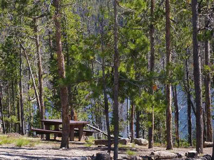
MOUNT HEYBURN CAMPGROUND · PLATE A-121
§ 01 — Opening Plate
A letter from the field
Idaho holds the largest wilderness complex in the Lower 48 — the Frank Church-River of No Return and Selway-Bitterroot together cover nearly four million unbroken acres, with no paved road across either one. Seventy-nine percent of the state is public land. The Sawtooth Mountains north of Stanley carry more than 700 alpine lakes and the rugged granite spine that gives the range its name; Redfish Lake mirrors all of it from 6,547 feet. Hells Canyon on the Oregon border is the deepest river gorge in North America at 7,913 feet from Hat Point down to the Snake. The Craters of the Moon lava flows record 15,000 years of basalt eruptions across the Snake River Plain. Up north, the Idaho Panhandle holds Priest Lake and 1,150-foot-deep Lake Pend Oreille. Add the Henrys Fork's blue-ribbon trout water and the Salmon River's 425 free-flowing miles, and no state outside Alaska holds this much wild river or this much wilderness in one map.
§ 02 — The Plates
Top 10 sites, filed
Mount Heyburn Campground
Sawtooth National Recreation Area's headline campground sits on the northwest shore of Redfish Lake at 6,547 feet, looking straight across the water at the granite teeth of Mount Heyburn (10,229 ft) and the Grand Mogul. Twenty paved sites under lodgepole pine accommodate tents and medium RVs. The Redfish Lake Lodge boat shuttle leaves from the marina a quarter mile south and drops backpackers at the head of the lake for Cramer Divide and the Sawtooth Wilderness. Reservable on Recreation.gov from late May through late September; sockeye salmon — Idaho's namesake redfish — still return up the Salmon River to spawn each August.
Stanley Lake Campground
Sawtooth NRA's quieter alternative to Redfish — 19 sites at 6,513 feet on the north shore of Stanley Lake, with the 9,860-foot McGown Peak rising straight off the south shore in one of the most photographed mountain reflections in the West. The Stanley Lake Creek Trail leaves from camp for Lady Face Falls (4.5 mi RT) and Bridalveil Falls (5 mi RT). Reservable on Recreation.gov from late May through mid-September. No hookups. The Salmon River headwaters run two miles down the highway, and the town of Stanley — population 100, elevation 6,260 feet — is six miles east.
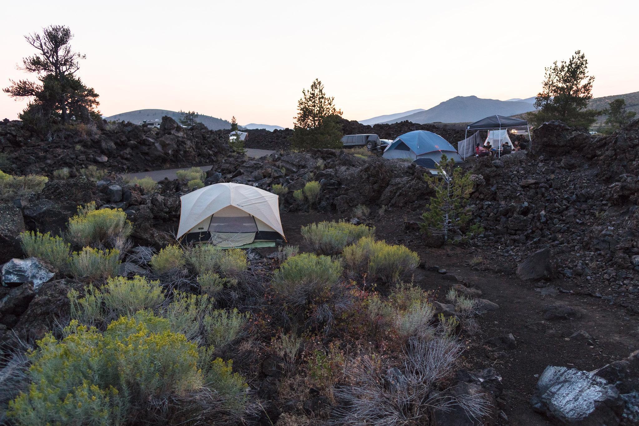
Lava Flow Campground
Craters of the Moon National Monument's only developed campground sits at 5,900 feet on a basalt flow that erupted roughly 2,000 years ago — the most recent of fifteen thousand years of volcanic episodes across the Snake River Plain. Forty-two sites carved out of the lava are shaded by limber pine and surrounded by black aa and pahoehoe formations. The Inferno Cone trail (0.4 mi up a 160-foot cinder cone) leaves from the loop road two miles north, and the Spatter Cones and Tree Molds trails follow. First-come, first-served year-round; no hookups, no shade trees of the size most campers expect, and night skies designated International Dark Sky.

Pittsburg Landing
Hells Canyon National Recreation Area's roaded campground sits at 1,300 feet on the Idaho side of the Snake River — at the bottom of the deepest river gorge in North America, with Hat Point on the Oregon rim rising 7,913 feet above the water. Twenty-eight sites spread across the riverside flat, accessible via 17 miles of Forest Road 493 from White Bird (gravel, steep in places, RV-capable but slow). The Snake River National Recreation Trail follows the east bank 30 miles upstream toward Granite Creek. Jet-boat shuttles operate from the landing into the wild section. Open year-round; no hookups; rattlesnake country.
- 05Outlet Campground at Priest LakeIdaho Panhandle National Forests' classic Priest Lake campground sits at the south outlet where…→
- 06City of Rocks CampgroundCity of Rocks National Reserve sits at 5,700 feet in southern Idaho's South Hills,…→
- 07Dworshak State Park — Freeman CreekIdaho's largest reservoir campground sits on Dworshak Reservoir at 1,600 feet — a 54-mile-long…→
- 08Buffalo CampgroundCaribou-Targhee National Forest's Island Park base sits at 6,200 feet on the Buffalo River,…→
- 09Glacier View CampgroundSawtooth NRA's south-side Redfish Lake campground — 65 sites on the lake's east shore…→
- 10Pine Flats CampgroundBoise National Forest's South Fork Payette River campground sits at 3,300 feet 25 miles…→
§ 03 — Field Data
The working page
Best Time
Everything is open. Sawtooth NRA campgrounds bind tight on six-month reservation windows — Redfish Lake's Mount Heyburn and Glacier View fill within minutes for July and August weekends. Stanley sits at 6,260 feet and can drop below freezing in any month — a 30°F night in mid-July is unremarkable. The Salmon River's Main and Middle Fork peak permit lottery runs through Recreation.gov in January for the following summer; private permits are notoriously hard to draw. Hells Canyon water temperatures climb and rattlesnake activity peaks. Wildfire smoke is the seasonal risk from mid-July onward — central Idaho carries the highest fire load of any state in the West most years.
Reservations
Permits & Signal
Both the Middle Fork of the Salmon (June through early September launches) and the Main Salmon (Wild and Scenic section, also called the River of No Return) use a single lottery on Recreation.gov. The application window…
Camping Etiquette
Yes on most USFS lands — Sawtooth, Salmon-Challis, Boise, Payette, Caribou-Targhee, Nez Perce-Clearwater, and Idaho Panhandle Forests all allow dispersed camping up to 16 days in a 30-day window inside any one Forest. Pull off existing…
§ 04 — Almanac
Four seasons, four readings
Spring
Mar–May
High-elevation Idaho stays snowbound. Sawtooth NRA campgrounds (Redfish, Stanley Lake) sit at 6,500-plus feet and typically open Memorial Day weekend. The Sawtooth Wilderness holds snow into July. Highway 21 from Lowman to Stanley closes seasonally for avalanche danger and reopens mid-April through May. Craters of the Moon is at 5,900 feet on the open Snake River Plain — accessible year-round, though wind and wide temperature swings make April and early May variable. Hells Canyon at 1,300 feet is at its best now: green hillsides, rattlesnake-pre-warmth, and rafting season starting to build. City of Rocks shoulder season runs through May with cool-rock conditions for traditional climbing. The Idaho Panhandle is wet and gray, and Priest Lake holds ice into April.
Summer
Jun–Aug
Everything is open. Sawtooth NRA campgrounds bind tight on six-month reservation windows — Redfish Lake's Mount Heyburn and Glacier View fill within minutes for July and August weekends. Stanley sits at 6,260 feet and can drop below freezing in any month — a 30°F night in mid-July is unremarkable. The Salmon River's Main and Middle Fork peak permit lottery runs through Recreation.gov in January for the following summer; private permits are notoriously hard to draw. Hells Canyon water temperatures climb and rattlesnake activity peaks. Wildfire smoke is the seasonal risk from mid-July onward — central Idaho carries the highest fire load of any state in the West most years.
Fall
Sep–Nov
The peak season for sockeye salmon viewing at Redfish Lake — late August through mid-September, when the fish that swam 900 miles from the Pacific up the Snake and Salmon to spawn are visible from the boardwalks. Larch turn gold in the northern panhandle and the Bitterroots in late September through mid-October. Highway 21 over Banner Summit can close in late October with the first heavy snow; Sawtooth NRA campgrounds shut down by late September. Hells Canyon stays in the 70s well into October — the best rafting weather of the year. Craters of the Moon shoulder season is excellent through October. Hunting seasons (elk, deer, antelope) open in September across most units; expect heavy backcountry use on USFS land.
Winter
Dec–Feb
Most of the state's developed campgrounds are closed and behind locked gates by Thanksgiving. Sun Valley and the Sawtooth crest hold deep snow — typically 10 to 15 feet at Galena Summit. Craters of the Moon stays open year-round, and Pittsburg Landing in Hells Canyon is accessible most winters, though the gravel road from White Bird can ice. City of Rocks stays open through mid-November before winter closure. Cross-country and skate ski networks run at Galena Lodge, Bogus Basin, and across the Boulder-White Cloud foothills. Cold-air-pool inversions trap fog and minus-20 mornings in the Stanley Basin — among the coldest reliable readings in the Lower 48.
§ 05A — Activity File
Best for Hiking & Backpacking
Idaho's hiking is built on the Sawtooth Wilderness's 217,000 acres of glaciated granite and 300-plus alpine lakes, Hells Canyon's mile-deep Snake River trench, the Frank Church-River of No Return Wilderness (the largest in the Lower 48), and the otherworldly basalt of Craters of the Moon. These four campgrounds anchor a representative slice.
Mount Heyburn Campground
Redfish Lake is the standard Sawtooth Wilderness front door — the Redfish Lake Lodge boat shuttle drops backpackers at the head of the lake for Cramer Divide, Alpine Lake, and the long route up to the Imogene Lake basin.
Stanley Lake Campground
The Stanley Lake Creek Trail leaves from camp for Lady Face Falls (4.5 mi RT) and Bridalveil Falls (5 mi RT), with the route continuing into the Sawtooth Wilderness toward Elizabeth Lake and Edna Lake.
Pittsburg Landing
The Snake River National Recreation Trail runs 30 miles upstream along the Idaho bank of Hells Canyon — a one-way shuttle backpack with jet-boat pickup from Granite Creek or further upstream the standard route.
Lava Flow Campground
Inferno Cone (0.4 mi up a 160-foot cinder cone), the Spatter Cones loop, and the Tree Molds Trail (2 mi RT through casts of trees burned 2,000 years ago) all leave from the loop road within two miles of camp.
§ 05B — Activity File
Best for RV Camping
Idaho's RV-friendly campgrounds split between one full-service state park, paved NPS loops at Craters of the Moon, and well-graded Forest Service loops with dump stations across the Sawtooths and Boise NF. Full hookups are rare on federal land — Dworshak State Park is the standout exception.
Dworshak State Park — Freeman Creek
Idaho's largest full-hookup state-park campground — 105 sites, mixed full-hookup, electric, and walk-in tent loops on a 54-mile reservoir, with paved roads and slide-out-friendly pads up to 90 feet.
Lava Flow Campground
Craters of the Moon's paved campground loop accommodates rigs up to 35 feet, with a dump station and potable water on site — no hookups, but open year-round, which is the rare thing in Idaho high-desert RV travel.
Pine Flats Campground
Twenty-seven sites at 3,300 feet on the South Fork Payette with riverside parking and easy turn-arounds for rigs up to 30 feet — closest paved-access RV camp to Boise on the Highway 21 corridor.
Mount Heyburn Campground
Paved Sawtooth NRA loops at 6,547 feet on Redfish Lake — no hookups, but a dump station, easy access from Highway 75, and accommodations for rigs up to 35 feet.
§ 05C — Activity File
Best for Whitewater & Wild Rivers
Idaho holds 3,100 miles of free-flowing whitewater — more than any state outside Alaska — including the Salmon River's Main and Middle Fork sections, the Selway, the Lochsa, the South Fork Payette, and the Snake through Hells Canyon. These four campgrounds open the gates.
Pittsburg Landing
Hells Canyon's roaded put-in for the Snake — commercial jet-boat and dory trips launch from the landing, and the Wild and Scenic section runs 32 miles downstream to Heller Bar through Class III–IV rapids in a mile-deep gorge.
Pine Flats Campground
The South Fork Payette is the most-rafted whitewater run in the western United States — Class III–V from the Staircase down through Rock Drop, with commercial outfitters launching from the campground itself.
Stanley Lake Campground
The Main Salmon River — designated Wild and Scenic, with 425 free-flowing miles and the Middle Fork put-in at Boundary Creek 35 miles up FR-668 — runs through Stanley two miles down the highway from Stanley Lake.
Buffalo Campground
The Henrys Fork of the Snake is the world-famous blue-ribbon dry-fly water for trout — Box Canyon, the Railroad Ranch stretch at Harriman State Park, and the Ranch riffles all sit within ten miles of camp.
§ 05D — Activity File
Best for Alpine Lakes & Sawtooths
The Sawtooth Mountains hold more than 700 alpine lakes inside a 217,000-acre wilderness, with glaciated granite peaks topping out at 10,751 feet on Thompson Peak. Up north, Priest Lake offers a different lake-country character — old-growth cedar and 1,150-foot Lake Pend Oreille nearby. These four cover both ends.
Mount Heyburn Campground
Redfish Lake at 6,547 feet under the Grand Mogul and Mount Heyburn — Idaho's signature alpine view and the standard photo of the Sawtooth NRA.
Glacier View Campground
Redfish Lake's south-shore loop with a sand beach and the lake's most direct trailheads for Fishhook Creek and the Bench Lakes basin in the Sawtooth Wilderness.
Stanley Lake Campground
Stanley Lake under McGown Peak — one of the most-photographed mountain reflections in the West, especially during early-morning calm before the afternoon thermals come up.
Outlet Campground at Priest Lake
Idaho Panhandle cedar-and-hemlock lake country — Priest Lake's lower basin with a wilderness lake (Upper Priest) reachable only by boat or trail, and Lake Pend Oreille's 1,150-foot depths an hour south.
§ 07 — Q & A
Frequently asked
It depends on the region. The Sawtooth Mountains and the Salmon River high country (Redfish Lake, Stanley Lake, Sawtooth Wilderness) run mid-June through September; trails clear of snow by July and freeze again by October. Hells Canyon and the lower Snake River are best March through May and September through October — summer pushes into the 100s in the canyon. The Panhandle (Priest Lake, Coeur d'Alene, Dworshak) peaks July and August with comfortable shoulder weeks in June and September. Craters of the Moon is open year-round but most pleasant in May and September. City of Rocks climbing season runs April through October. Island Park and the Henrys Fork dry-fly season runs late June through early October.
§ 08 — Adjacent Sheets