FIELD GUIDE · CHAPTER 37 · REGION IEST. 2026
Oregon
The Beaver State
OR · 43°56′ N · 120°33′ W · 970 SITES SURVEYED
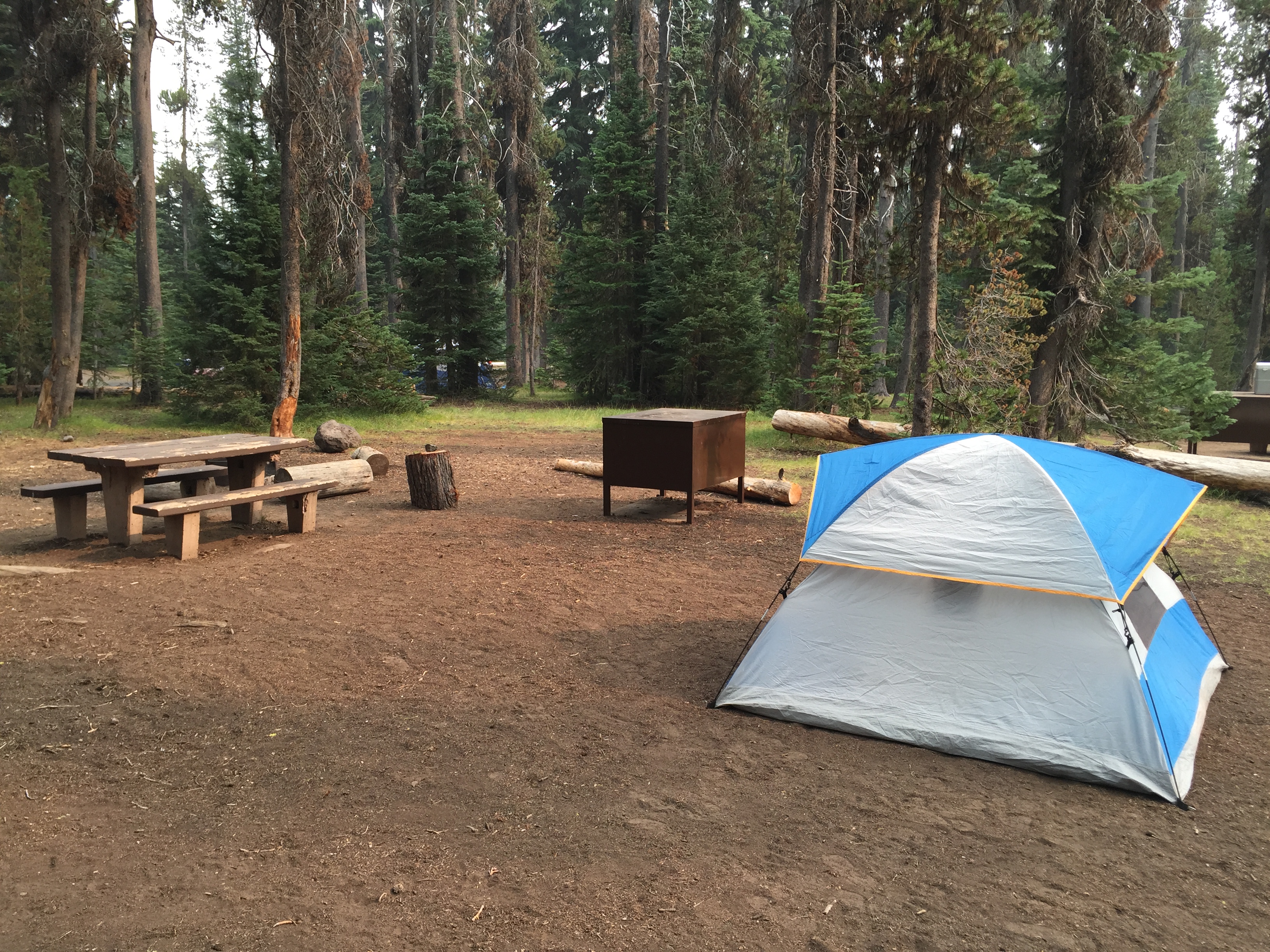
MAZAMA CAMPGROUND · PLATE A-371
§ 01 — Opening Plate
A letter from the field
Oregon condenses more terrain into a single state border than almost anywhere in the Lower 48 — sea-level rainforest on the Pacific to 11,249 feet on Mount Hood, the deepest lake in the country at Crater Lake, the high desert of the Steens rising 5,500 feet straight off the Alvord playa, and the basalt walls of the Columbia Gorge. The 1967 Beach Bill made every inch of the 363-mile coastline public, the only state in the country with that protection, and Oregon's State Parks anchor the developed coast camping network alongside USFS sites like Cape Perpetua. Inland, the Cascade Lakes Scenic Byway threads past Three Sisters volcanoes, the Wallowas earn the Switzerland-of-America label in the northeast corner, and Hells Canyon drops deeper than the Grand at the Idaho line. Add the densest concentration of waterfalls in North America in the Gorge, and Oregon delivers.
§ 02 — The Plates
Top 10 sites, filed
Mazama Campground
Crater Lake National Park's main campground, 214 sites at 6,000 feet in lodgepole pine 7 miles from the south rim. Open only mid-June through mid-October, snowpack-dependent — Mount Mazama collapsed 7,700 years ago to form the deepest lake in the United States at 1,943 feet. Half the loops are tent-only, the rest take RVs with hookups in select sites; generators allowed during park hours. Recreation.gov six months ahead and the first summer weekend disappears within minutes. Garfield Peak and Watchman Peak trails are short drives along Rim Drive.
Trillium Lake Campground
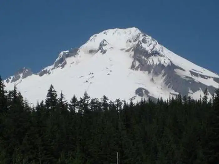
Mt. Hood National Forest, 57 sites at 3,600 feet on the south shore of Trillium Lake, 6 miles south of Government Camp on FR-2656. The Mt. Hood reflection across this lake is the most-photographed Cascade volcano view in the country, and you can paddle out to the middle and shoot it yourself at dawn. Drive-in loops with tent and small-to-medium RV sites, no hookups. Non-motorized lake — canoe, kayak, paddleboard only. Late May through October, reserve through Recreation.gov.

Cape Perpetua Campground
Siuslaw National Forest on the central coast, 3 miles south of Yachats on US-101. Roughly 38 sites along Cape Creek under old-growth Sitka spruce, a quarter-mile from the Devil's Churn and Spouting Horn — explosive tide-driven chasms in the basalt headland. The Saint Perpetua Trail climbs 800 feet to a 1933 CCC shelter with the best whale-watching perch on the coast; gray whales pass in December and again March through April. Recreation.gov reservable, typically mid-March through October.

Tahkenitch Campground
Siuslaw National Forest inside the Oregon Dunes National Recreation Area, 23 miles south of Florence on US-101. 36 sites tucked under shore pine and salal at Tahkenitch Lake — the name means "lake of many arms" in the Siuslaw language, a freshwater finger lake pressed up against the coastal dunes. The Tahkenitch Dunes Trail (5 miles round trip) climbs through open sand and drops onto a long stretch of empty beach. Smaller and more rustic than the State Park alternatives. No hookups. Recreation.gov reservable.
- 05Sparks Lake Boating SiteDeschutes National Forest on the Cascade Lakes Scenic Byway at 5,450 feet, primitive boating-site…→
- 06Chimney Rock CampgroundBLM Prineville District on the Lower Crooked Wild and Scenic River, 14 miles south…→
- 07Moss Springs CampgroundWallowa-Whitman National Forest on the west flank of the Wallowa Mountains at 5,800 feet,…→
- 08Edson Creek CampgroundBLM Coos Bay District on the lower Sixes River, 6 miles inland from where…→
- 09Page Springs CampgroundBLM Burns District near Frenchglen at the foot of Steens Mountain, 30 sites on…→
- 10Eagle Creek CampgroundMt. Hood National Forest in the Columbia Gorge near Bonneville Dam — the first…→
§ 03 — Field Data
The working page
Best Time
Dry-summer Mediterranean west of the Cascades — almost no rain falls June through September, and the forest dries out fast. Wildfire smoke risk runs from mid-July through early October and can erase Cascade views for days. Crater Lake's Mazama Campground typically opens mid-to-late June, and the Cascade Lakes Highway clears by late June. The coast stays in the 60s — it never gets hot, and afternoons often fog in from the marine layer. Eastern Oregon climbs into the 90s and beyond. Reservation lottery binds tightly on the coast and the Cascades from Memorial Day through Labor Day.
Reservations
Permits & Signal
Camping Etiquette
State parks welcome leashed dogs throughout most loops and trails, with very few exceptions. USFS campgrounds are similarly pet-friendly — dogs on a six-foot leash on most trails. Crater Lake National Park, like all national parks,…
§ 04 — Almanac
Four seasons, four readings
Spring
Mar–May
Wet-and-gray on the west side. The Coast Range and the valley stay in the 50s with steady rain through May, but the coast itself is shoulder-ready — cold, wet, and often foggy, with no snow to worry about and Beach Bill access to every mile. Cascade high country is still snowbound: Trillium Lake Campground stays gated through May on a snowpack-dependent schedule, and Crater Lake's Rim Drive routinely holds snow into July. The Steens Loop Road remains gated on the east side. Columbia Gorge waterfalls run at peak flow — Multnomah Falls at full thunder is the spring set piece.
Summer
Jun–Aug
Dry-summer Mediterranean west of the Cascades — almost no rain falls June through September, and the forest dries out fast. Wildfire smoke risk runs from mid-July through early October and can erase Cascade views for days. Crater Lake's Mazama Campground typically opens mid-to-late June, and the Cascade Lakes Highway clears by late June. The coast stays in the 60s — it never gets hot, and afternoons often fog in from the marine layer. Eastern Oregon climbs into the 90s and beyond. Reservation lottery binds tightly on the coast and the Cascades from Memorial Day through Labor Day.
Fall
Sep–Nov
The highest wildfire window runs late September through October before the autumn rains return. Cascade Lakes Highway gates by mid-October, and Crater Lake's Rim Drive typically closes the first week of November. The east side is the broad sweet spot — cooler, drier, and quieter than the summer scramble, with vine maple turning crimson at Multnomah Falls in late October. The coast tends to be clearest in September and early October, the marine fog finally burning off into the open Pacific blue stretches that summer rarely delivers. Reservations relax after Labor Day on most loops outside Crater Lake.
Winter
Dec–Feb
Wet on the west side, snow-locked above 4,000 feet. Crater Lake's south entrance stays open year-round for ski-in rim access, though Mazama Campground is closed and the road to the north entrance gates by November. Mt. Hood's ski resorts — Timberline, Meadows, and Skibowl — anchor winter activity, and snow-park permits open USFS sno-parks across the Cascades. The coast remains accessible and shifts into storm-watching season, with king tides drawing crowds to the headlands at Cape Perpetua and Cape Lookout. Steens Loop Road stays gated October through June; the high desert is winter-only for the prepared.
§ 05A — Activity File
Best for Hiking & Backpacking
Oregon's hiking story is the Cascade volcanic crest — Crater Lake's rim trails, the Three Sisters complex, and the Eagle Cap Wilderness in the northeast corner. Add the high-desert canyon of the Lower Crooked River for a basalt rim-rock alternative, and these four campgrounds put you at the trailheads.
Mazama Campground
Garfield Peak (3.4 miles round trip, 1,000 feet of gain) and Watchman Peak (1.6 miles round trip) leave directly from Rim Drive, both delivering the full caldera view above the lake.
Sparks Lake Boating Site
Basecamp for South Sister climbers — the standard route up Oregon's third-tallest peak starts at the Devils Lake trailhead 4 miles south. Le Conte Crater and Rock Mesa lava flows are easy day objectives.
Chimney Rock Campground
Rim-rock day hikes climb out of the Lower Crooked River canyon to the basalt spires above camp, and fly anglers work the riffles for native redband trout in the Wild and Scenic stretch.
Moss Springs Campground
The trailhead at camp drops into the Eagle Cap Wilderness via Catherine Creek Meadows and Burger Pass — quieter west-side access than the Wallowa Lake trams on the east, with the same alpine basins.
§ 05B — Activity File
Best for RV Camping
Oregon's federal-land RV story is unusual in two ways: Crater Lake National Park actually offers hookup sites in select Mazama loops, and the rest of the top federal RV options run on paved drive-in loops with no hookups. Most full-hookup coast camping happens at State Parks not in this top 10 — these four are the federal alternatives.
Mazama Campground
The only car-camping inside Crater Lake National Park, with hookups in select loops — unusual for an NPS unit. Mid-June through mid-October only, generators allowed during park hours.
Tahkenitch Campground
Smaller and quieter than the big State Park options — 36 sites, no hookups, but the loops accommodate medium rigs under shore pine on a non-motorized freshwater lake adjacent to the dunes.
Cape Perpetua Campground
Roughly 38 sites along Cape Creek with RV-accessible loops, no hookups but a quiet old-growth canopy. Reservable on Recreation.gov mid-March through October — the longest coastal-federal season in this list.
Trillium Lake Campground
Six miles south of Government Camp on a paved forest road, with drive-in loops sized for medium rigs and no hookups. Non-motorized lake; canoe out at dawn for the Mt. Hood reflection.
§ 05C — Activity File
Best for Cascade Volcanoes & Alpine Lakes
The Oregon Cascades are a chain of stratovolcanoes from Mt. Hood to Mt. McLoughlin. Mount Mazama collapsed 7,700 years ago to form Crater Lake — the most recent major eruption on the chain. The Three Sisters are the largest contiguous volcanic complex in Oregon, and Mt. Hood is the most-climbed glaciated peak in North America. These three campgrounds anchor the chain.
Mazama Campground
Seven miles from the south rim and Rim Drive's 33-mile circuit past Vidae Falls, Phantom Ship Overlook, and the Cleetwood Cove trailhead — the only legal descent to the lake itself.
Trillium Lake Campground
The Mt. Hood reflection across this glacier-fed lake at 3,600 feet is the archetypal Cascade volcano image — paddle a canoe out at dawn for the still-water shot photographers wait years for.
Sparks Lake Boating Site
Cascade Lakes Scenic Byway position at 5,450 feet puts South Sister, Broken Top, and Mt. Bachelor on the backdrop simultaneously — the densest Three Sisters viewing camp on the byway.
§ 05D — Activity File
Best for Oregon Coast Camping
The 1967 Oregon Beach Bill made all 363 miles of coastline public from the high tide line to the vegetation line — the only US state with that rule. The developed State Park system (Cape Lookout, Honeyman, Nehalem Bay, and others) handles most coast car-camping. These two USFS coast sites plus a south-coast BLM river camp offer a quieter take.
Cape Perpetua Campground
An 800-foot basalt headland with the Devil's Churn and Spouting Horn tide-driven chasms a quarter-mile from camp; the Captain Cook Trail drops to the tide pools and Spouting Horn while the Saint Perpetua Trail climbs to the headland whale-watching perch.
Tahkenitch Campground
The Tahkenitch Dunes Trail (5 miles round trip) climbs through open sand and drops onto a long empty beach. A freshwater swim lake sits at the base of the dunes back at camp.
Edson Creek Campground
Six miles inland on the Sixes River corridor — south-coast river camping for fall Chinook and winter steelhead anglers, with the Cape Blanco lighthouse and the open Pacific a short drive west.
§ 07 — Q & A
Frequently asked
It depends on the region. Cascade high country — Crater Lake, the Three Sisters, Mt. Hood above Government Camp — runs mid-June through September, snowpack-dependent. The coast is technically year-round but driest in September and October and warmest in July and August, with the marine layer keeping afternoons cool. The east side and Steens Mountain run May through October, peaking July through September after the Steens Loop Road opens. The Columbia Gorge waterfalls peak April through October, with camping reliable May through October. Reservation lottery binds tightly on the coast from Memorial Day through Labor Day — book six months ahead on Recreation.gov for federal sites and oregonstateparks.org for State Parks.
§ 08 — Adjacent Sheets