
FIELD GUIDE · CHAPTER 44 · REGION IIEST. 2026
Utah
The Beehive State
UT · 39°18′ N · 111°40′ W · 985 SITES SURVEYED
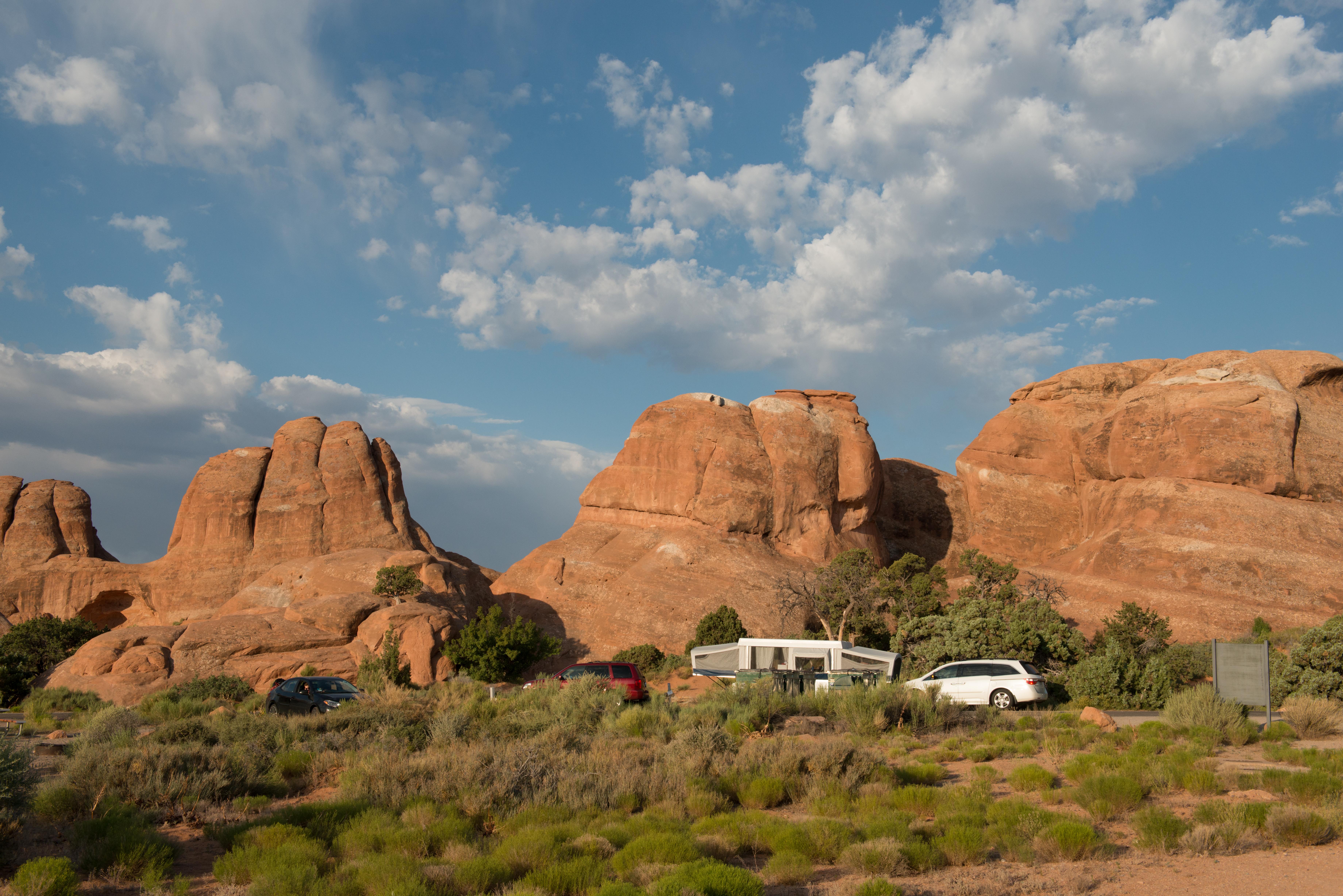
WATCHMAN CAMPGROUND · PLATE A-441
§ 01 — Opening Plate
A letter from the field
Utah hosts five national parks in a red-rock belt south of I-70, and no other state packs that density of sandstone into a single weekend-length drive. Zion's 2,000-foot Navajo walls in the southwest, Bryce Canyon's hoodoo amphitheaters above 8,000 feet, Capitol Reef's Waterpocket Fold, Arches' 2,000 cataloged natural arches, and Canyonlands' three roadless districts together define the American canyon country. North of the Mighty Five, the Uinta Mountains rise to 13,528 feet at Kings Peak and form the only major east-west range in the Lower 48, with cold alpine lakes and the Mirror Lake Scenic Byway crossing at 10,700 feet. The Wasatch Front above Salt Lake City adds granite canyons and 500 inches of annual snowfall, and Glen Canyon National Recreation Area pools the Colorado River into Lake Powell along the Arizona border. Utah's range — from slickrock desert to alpine tundra in a two-hour drive — is unmatched in the contiguous United States.
§ 02 — The Plates
Top 10 sites, filed
Watchman Campground
Zion's flagship campground sits inside the south entrance along the Virgin River with 176 sites beneath the 2,555-foot face of the Watchman itself. Reservations through Recreation.gov open six months out and sell out within minutes for spring and fall weekends — summer is only marginally easier because of 100°F+ canyon heat. A free shuttle from camp runs the entire scenic drive into the upper canyon (Angels Landing, the Narrows, Observation Point). Loops A and B accommodate RVs to 40 feet with electric hookups; loop C is tent-only. Cottonwood shade keeps mornings cool; afternoons require the river.
Devils Garden Campground
The only campground inside Arches National Park, with 51 sites carved into slickrock and juniper 18 miles from the visitor center. Devils Garden sits at the end of the scenic drive — step out of camp and you're on the trail to Landscape Arch and the Primitive Loop past Double O Arch and Dark Angel. Reservations are required March through October and open six months in advance on Recreation.gov; the campground books within the first hour of release. No hookups, minimal shade, dry firewood sold at the visitor center. Arches' timed-entry reservation system does not apply to campground holders.
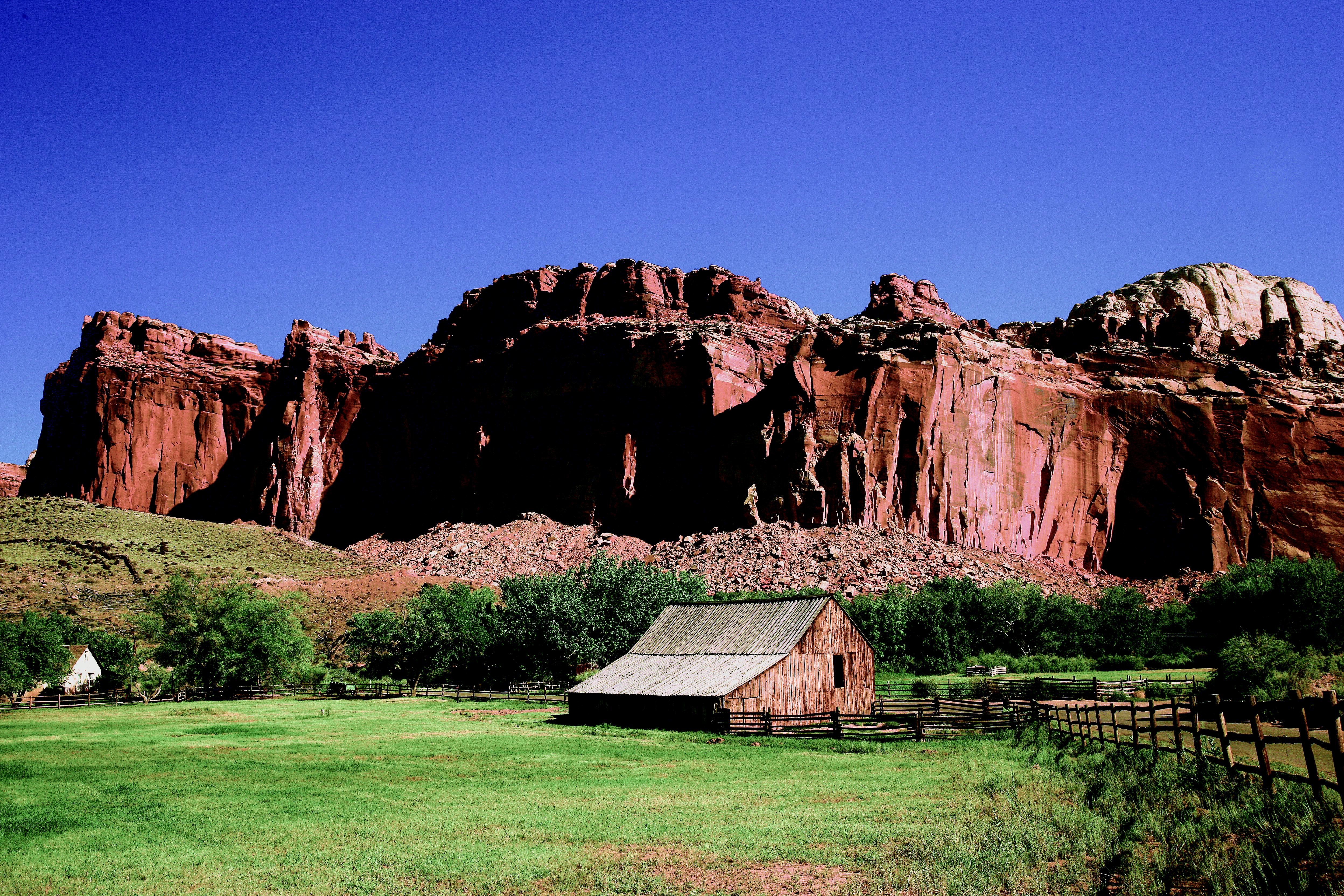
Fruita Campground
An orchard campground — genuinely. The 71 sites at Fruita sit inside a working historic fruit orchard planted by Mormon pioneers in the 1880s; you can pick apples, pears, apricots, and cherries in season straight from the campground loops. Capitol Reef's Scenic Drive starts at the campground exit and climbs through the Waterpocket Fold past petroglyphs and the Hickman Bridge trailhead. The Fremont River runs past the orchard. Reservations are required March through October; a small first-come block fills before noon. No hookups, modern restrooms, a dump station on the way out.
Sunset Campground
Bryce Canyon's most scenic campground, named for Sunset Point — a 5-minute walk to the rim where the hoodoo amphitheater lights up orange at last light. At 8,000 feet, Sunset is dramatically cooler than the Mighty Five's desert parks even in July, and loops stay in ponderosa pine shade all day. Loop A accepts RVs up to 30 feet; loops B and C are tent-oriented. Reservations are required May 15 through October 15 through Recreation.gov. Cold nights year-round — the shoulder seasons drop into the 30s and the campground closes by the first heavy snow, usually late October.
- 05The Needles CampgroundCanyonlands' Needles District is the park's hiking heart, and Squaw Flat Campground puts you…→
- 06Willow Flat CampgroundCanyonlands' Island in the Sky is a 6,000-foot mesa between the Green and Colorado…→
- 07Mirror Lake CampgroundThe Mirror Lake Scenic Byway crests the Uintas at 10,700 feet, and Mirror Lake…→
- 08Spruces CampgroundSpruces sits at 7,400 feet in Big Cottonwood Canyon east of Salt Lake City,…→
- 09Warner Lake CampgroundAn alpine escape from Moab's desert heat. Warner Lake's 20 sites sit at 9,200…→
- 10Lone Rock BeachA vast primitive camping area on a Lake Powell beach in Glen Canyon National…→
§ 03 — Field Data
The working page
Best Time
Peak season, but heavily stratified by elevation. Zion, Arches, and Canyonlands run 95–105°F with no real shade — hiking windows compress to pre-8 AM and post-6 PM. The Uintas, Wasatch, and La Sals stay in the 70s at campground elevation and are the state's relief valve. The North American monsoon arrives mid-July through mid-September with daily afternoon thunderstorms — lightning above 10,000 feet and flash floods in every slot south of I-70. Arches requires timed-entry reservations April through October, and Bryce's shuttle becomes mandatory for some trailheads in summer.
Reservations
Arches requires timed-entry vehicle reservations April 1 through October 31, released on Recreation.gov in monthly blocks three months in advance with a smaller next-day block at 7 PM Mountain Time. Zion does not currently have a…
Permits & Signal
Yes. BLM and USFS dispersed camping is free across most of Utah's public land, and the state has the third-highest percentage of federal land in the country. Popular free areas include the BLM corridors around Moab…
Camping Etiquette
State parks and USFS campgrounds are generally pet-friendly with leashed dogs welcome on trails. National parks are far more restrictive — Zion, Arches, Bryce, Canyonlands, and Capitol Reef all restrict pets to campgrounds, paved roads, parking…
§ 04 — Almanac
Four seasons, four readings
Spring
Mar–May
The best desert camping season. The Mighty Five run 65–80°F in the afternoons from mid-March through May, cottonwoods leaf out along the Virgin and Fremont rivers, and the Moab slickrock is cool enough to hike all day. The trade-off is the Uintas, Wasatch, and La Sals, which stay snowbound through May — Mirror Lake Scenic Byway typically gates until late June. Reservations open six months in advance and the spring shoulder weekends at Watchman, Devils Garden, and Fruita sell out the morning the window opens. Flash-flood risk rises from April onward; check forecasts before entering slot canyons.
Summer
Jun–Aug
Peak season, but heavily stratified by elevation. Zion, Arches, and Canyonlands run 95–105°F with no real shade — hiking windows compress to pre-8 AM and post-6 PM. The Uintas, Wasatch, and La Sals stay in the 70s at campground elevation and are the state's relief valve. The North American monsoon arrives mid-July through mid-September with daily afternoon thunderstorms — lightning above 10,000 feet and flash floods in every slot south of I-70. Arches requires timed-entry reservations April through October, and Bryce's shuttle becomes mandatory for some trailheads in summer.
Fall
Sep–Oct
Many locals' favorite season. September pulls the heat out of the desert, the Uinta quaking aspens turn gold by mid-month, and the Mighty Five crowds drop sharply after Labor Day. Fruita's apple and pear harvest runs through September — pick your breakfast from the campground orchard. Bryce and the Uintas get their first significant snow by mid-October; Mirror Lake Scenic Byway typically closes by October 20. Watchman, Devils Garden, and Fruita stay reservable through October. Wildfire smoke is less of a factor in Utah than in the Northern Rockies but checks airnow.gov if fires are active.
Winter
Nov–Feb
Zion and the southwest desert parks remain open with dramatically reduced crowds; Watchman stays reservable year-round and the Narrows in fresh snow is one of the state's most surreal scenes (dry suit required for water). Bryce at 8,000 feet gets 100+ inches of snow annually; Sunset closes but the park plows the main road and groomed cross-country ski tracks replace summer trails. Arches and Canyonlands remain open with minimal services. The Uintas, Wasatch, and La Sals are closed to vehicle camping — the Mirror Lake Scenic Byway is a groomed snowmobile route through spring.
§ 05A — Activity File
Best for Hiking & Canyoneering
Utah's hiking is defined by slickrock, slot canyons, and some of the most exposed trail in the national park system. The Mighty Five each offer their own signature hikes — Angels Landing, the Narrows, the Navajo Loop, Delicate Arch, the Chesler Park Loop — and these campgrounds put you at the trailheads.
Watchman Campground
Zion's shuttle from camp reaches Angels Landing, the Narrows, Observation Point, and the West Rim — four of the most iconic hikes in the national park system, all within 10 shuttle stops.
The Needles Campground
The Chesler Park Loop, Druid Arch, and Joint Trail all leave from within a few miles of camp — the best concentration of slickrock loop hikes in Canyonlands.
Devils Garden Campground
The Primitive Loop past Landscape, Double O, and Dark Angel arches leaves directly from camp — the longest trail inside Arches and the one that empties of crowds after the first mile.
Fruita Campground
Hickman Bridge, Cassidy Arch, and the Navajo Knobs trail all start within 3 miles of camp on Capitol Reef's Scenic Drive — a compact network of Waterpocket Fold classics.
§ 05B — Activity File
Best for Climbing
Utah is the most important desert climbing state in the country. Indian Creek's splitter cracks, Zion's big walls, and the Fisher Towers near Moab together define American crack climbing, and Joe's Valley and the Wasatch add world-class bouldering and sport to the mix. These campgrounds put you closest to the approach.
The Needles Campground
The closest developed campground to Indian Creek — a 45-minute drive to the Supercrack Buttress, Battle of the Bulge, and the splitters that define modern American crack climbing.
Devils Garden Campground
Closest NPS camp to the Fisher Towers, Castle Valley, and the sandstone towers of the Moab corridor — Ancient Art and Castleton Tower are under an hour out.
Watchman Campground
Zion's Moonlight Buttress, Spaceshot, and Prodigal Son big-wall routes are staged from the Watchman — permits required, but the approaches start from the campground shuttle stops.
§ 05C — Activity File
Best for Water Sports
Utah's water country clusters around three basins: Lake Powell's 1,900 miles of Glen Canyon shoreline, the Uinta Mountain lakes above 10,000 feet, and the alpine reservoirs of the La Sal and Wasatch ranges. These campgrounds put a boat launch, swim beach, or paddle dock within walking distance.
Lone Rock Beach
Park on the sand, launch a boat from camp — Lone Rock is one of the only drive-on-the-beach RV spots in the country, with Lake Powell's full 186-mile length to explore from the kayak or ski.
Mirror Lake Campground
The lake itself is the attraction — stocked trout, kayakable the entire surface, and a glass-smooth mirror on calm Uinta mornings with Bald Mountain reflected whole.
Warner Lake Campground
A quiet brook-trout lake at 9,200 feet — hand-launchable kayaks and canoes, no motors, and a shoreline loop trail that circles the entire lake in 20 minutes.
§ 05D — Activity File
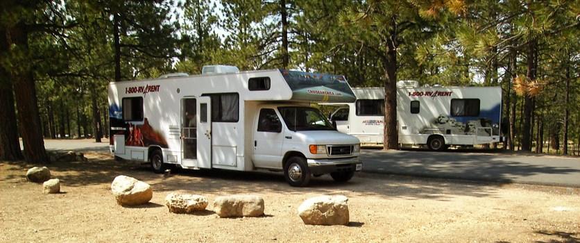
Best for RV Camping
Utah's NPS campgrounds were built in the mid-20th century and most accept rigs to 30–40 feet, but only Watchman has electric hookups inside a national park. For full hookups, private parks around Moab, Springdale, and Kanab fill the gap. These are the strongest federal RV-friendly options.
Watchman Campground
The only NPS campground in Utah with electric hookups (30 and 50 amp in loops A and B), plus a dump station and pull-through sites to 40 feet. The flagship RV option inside the Mighty Five.
Devils Garden Campground
Accommodates RVs up to 40 feet with a dump station at the visitor center. No hookups, but level pads and generator hours make it workable for self-contained rigs.
Sunset Campground
Bryce's loop A accepts RVs to 30 feet; no hookups, but the 8,000-foot elevation means AC is rarely necessary and the general store at Bryce Canyon Lodge has a dump station.
Fruita Campground
Pull-through sites accommodate rigs to 40 feet with a dump station on the exit road. The Fremont River provides unusual (for Utah) canyon-country shade on the RV loops.
§ 07 — Q & A
Frequently asked
For the Mighty Five and the southern red-rock parks, April through mid-May and mid-September through October are ideal — daytime highs 70–80°F, cottonwoods leafing out in spring or aspen gold in fall, and summer crowds either not yet arrived or already gone. For the Uintas, Wasatch, and La Sals, peak camping is July through early September; most of the high country stays snowbound until late June. Summer in the desert parks is brutally hot — 100°F+ is routine at Zion, Arches, and Canyonlands from late June through early September.
§ 08 — Adjacent Sheets