FIELD GUIDE · CHAPTER 43 · REGION IIIEST. 2026
Texas
The Lone Star State
TX · 31°29′ N · 99°20′ W · 924 SITES SURVEYED
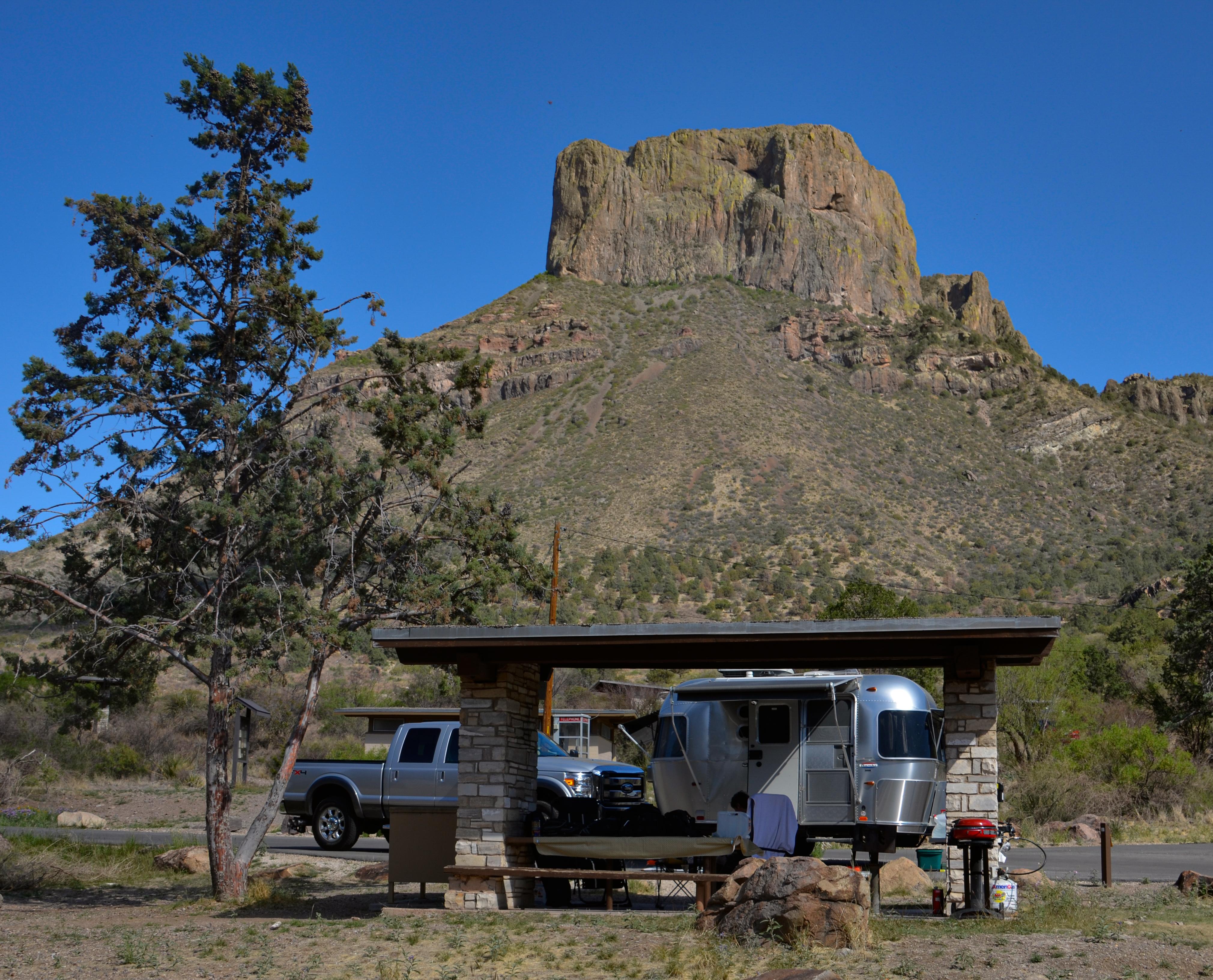
CHISOS BASIN CAMPGROUND — BIG BEND NATIONAL PARK · PLATE A-431
§ 01 — Opening Plate
A letter from the field
Texas is so large that its camping spans climate zones most states never touch. Drive far enough and you cross from the Chihuahuan Desert mountains of Big Bend to the Gulf Coast barrier-island beaches of Padre Island, from the loblolly shade of the East Texas Piney Woods to the canyon country of Lake Meredith in the Panhandle, then back to the cedar-and-limestone lakes of the Hill Country. The headline federal landscapes anchor each region: Big Bend and Guadalupe Mountains national parks, Padre Island National Seashore, the Amistad and Lake Meredith national recreation areas, and four national forests. The twist is ownership — roughly 95% of Texas is private land, so public camping concentrates on these federal holdings and on the separately reserved state-park system. What makes it singular: Big Bend's International Dark Sky skies, a barrier island you can drive and sleep on, and one state that runs from desert to subtropics.
§ 02 — The Plates
Top 10 sites, filed
Chisos Basin Campground — Big Bend National Park
The only mountain campground in Big Bend, set in a bowl of the Chisos at about 5,400 feet where the air runs meaningfully cooler than the desert floor below. Roughly 60 sites, reservation-only on Recreation.gov, ringed by Casa Grande and the famous notch called the Window. The winding access road bans large RVs and long trailers, so come small. Window, Lost Mine, Emory Peak, and South Rim trailheads leave from camp, black bears and javelina wander the loops, and after dark the sky over the rim turns dense with stars.
Rio Grande Village — Big Bend National Park
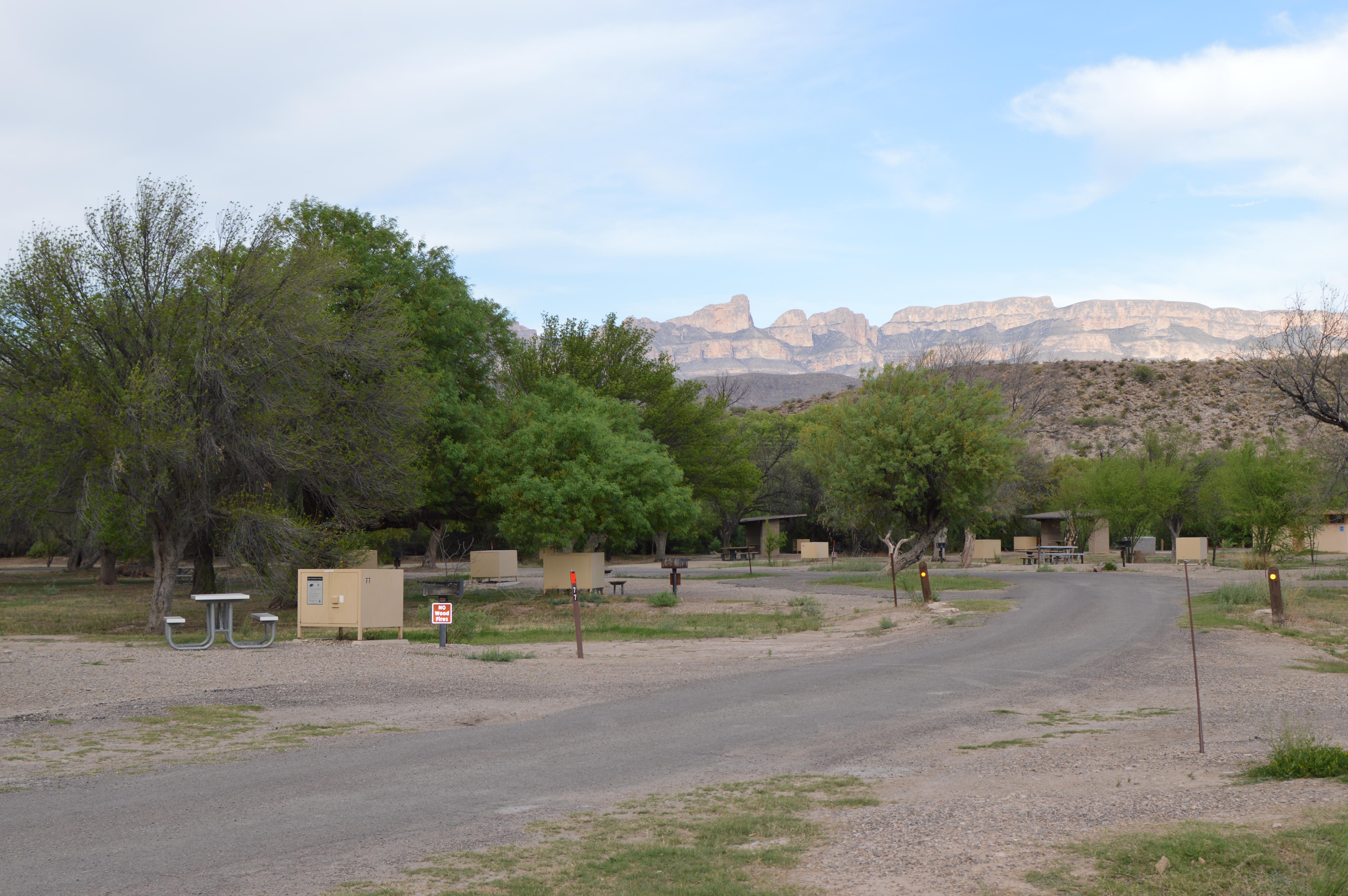
Big Bend's largest campground, around 100 sites in the warm southeast corner at about 1,850 feet right along the Rio Grande, shaded by big cottonwoods. The adjacent concession holds the only RV hookups in the park, and the boardwalk Nature Trail over a spring-fed wetland is one of the premier birding spots in Texas. Boquillas Canyon, the Boquillas border crossing into Mexico, and Langford Hot Springs all sit minutes away. This is the mildest winter camping in the park — a snowbird favorite when the high country turns cold.
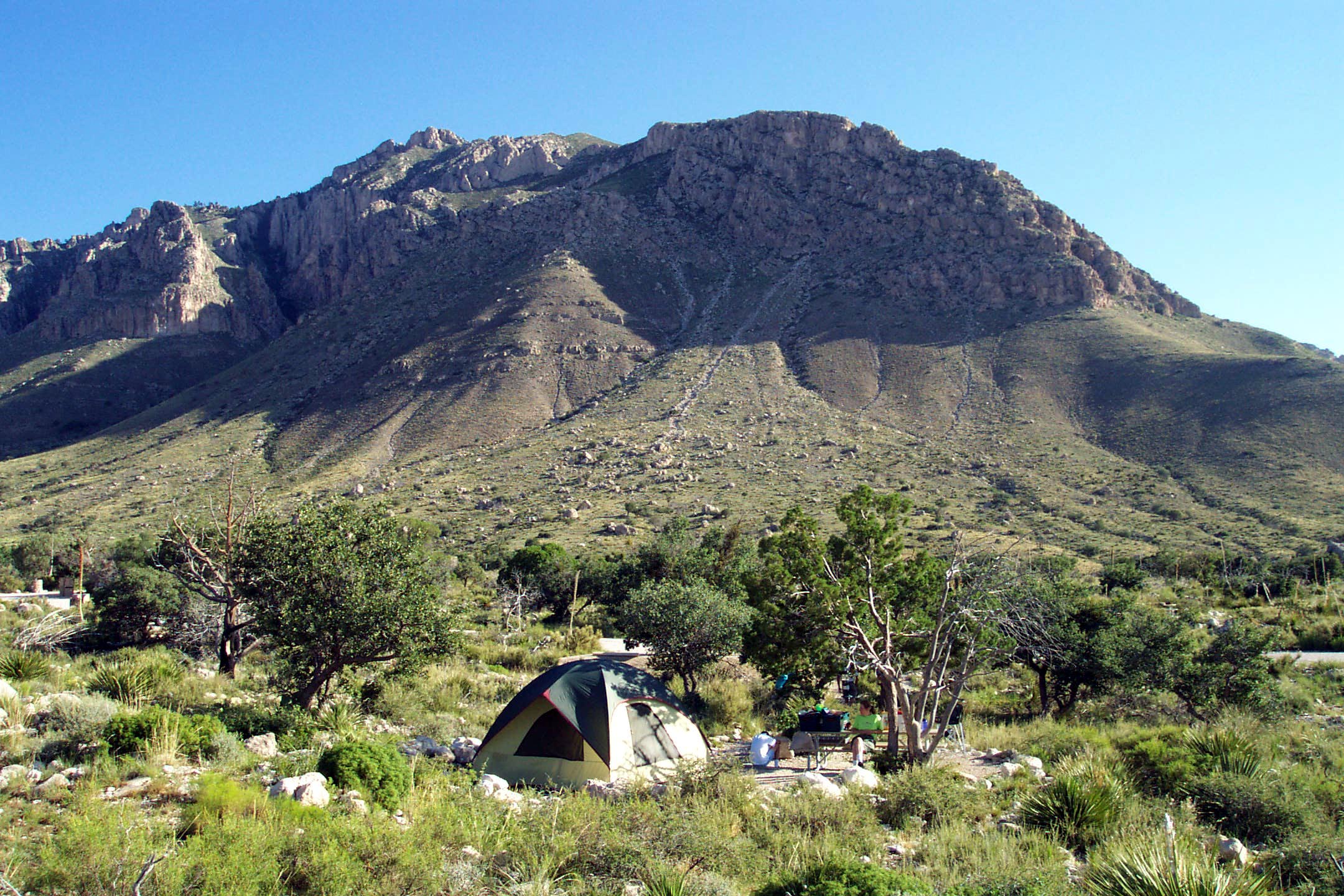
Pine Springs — Guadalupe Mountains National Park
At about 5,800 feet beside the Guadalupe Mountains visitor center off US-62/180, with roughly 20 tent and 19 RV sites and no hookups, all reservable. This is the launch point for Guadalupe Peak — 8.4 miles round trip to the highest point in Texas at 8,751 feet — and for the cliff-walled Devil's Hall route, with McKittrick Canyon's blazing fall foliage a short drive north. The wind here is notorious, screaming down off the escarpment and rattling tents all night, so stake everything hard. No ground fires are permitted.
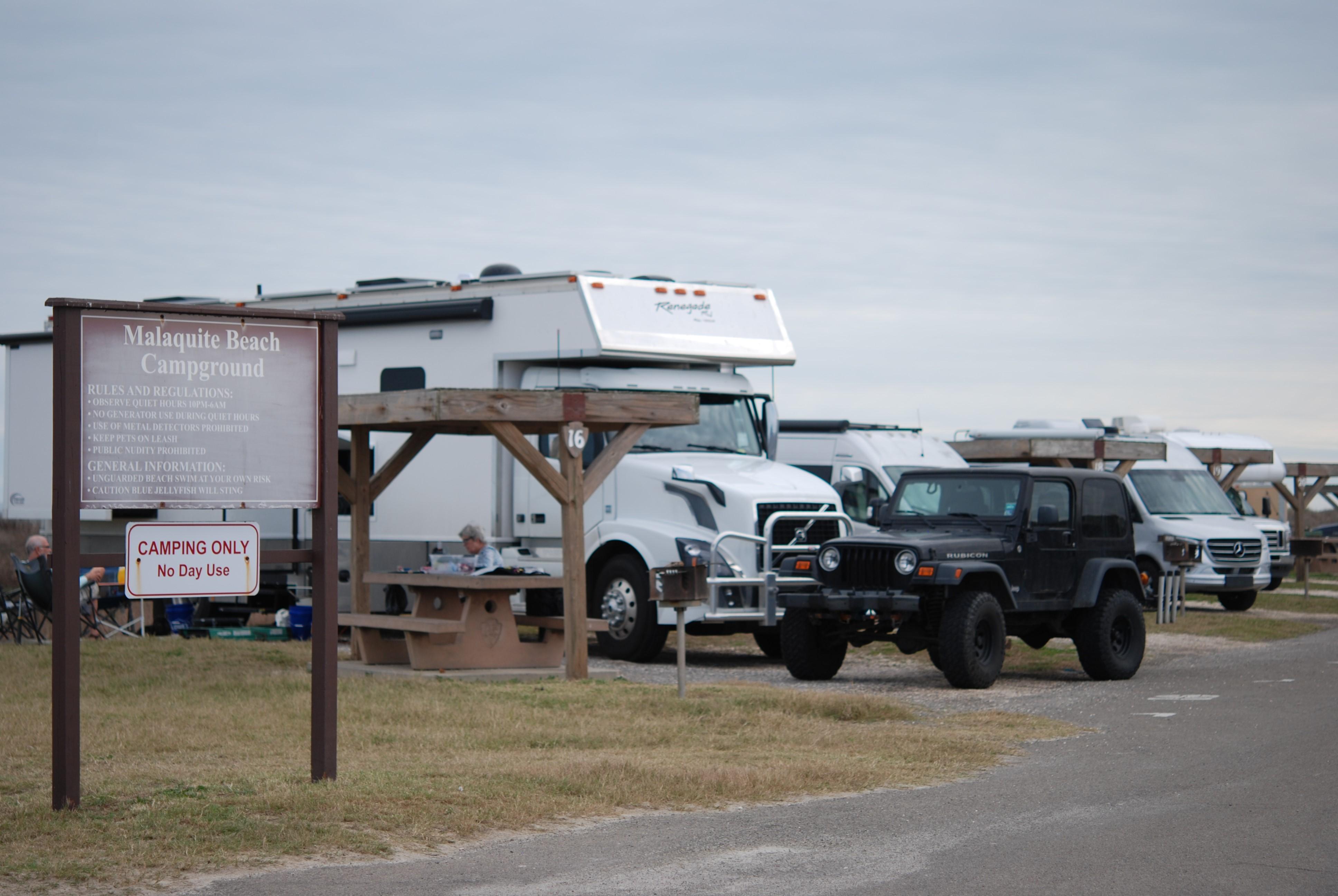
Malaquite Campground — Padre Island National Seashore
On the Gulf shore of Padre Island National Seashore, the longest undeveloped barrier island in the world. Paved semi-primitive sites cluster by the visitor center with restrooms and cold rinse showers but no hookups, and free drive-on beach camping stretches for miles south by permit once you pass the 5-mile marker in 4WD. Kemp's ridley sea turtles nest here, and the park hosts public hatchling releases through summer. Shade is almost nonexistent and the wind and sun are relentless, but waking to surf a few steps away is the trade.
- 05Governors Landing — Amistad National Recreation AreaA shaded NPS campground near the dam on Lake Amistad, the big clear reservoir…→
- 06Sanford Yake — Lake Meredith National Recreation AreaA developed campground perched above the Sanford-Yake marina and boat ramp on Lake Meredith,…→
- 07Double Lake Recreation Area — Sam Houston National ForestA CCC-built lake tucked into the Sam Houston National Forest near Coldspring, an easy…→
- 08Ratcliff Lake Recreation Area — Davy Crockett National ForestA 45-acre CCC lake set deep in the Davy Crockett National Forest near Kennard,…→
- 09Potters Creek Park — Canyon LakeThe most popular Corps of Engineers campground on Canyon Lake, a deep clear Hill…→
- 10Cedar Ridge Park — Belton LakeA Corps of Engineers campground on Belton Lake, formed on the Leon River near…→
§ 03 — Field Data
The working page
Best Time
The peak season for Texas. The Hill Country's Balcones Escarpment corridor is the first hazard to plan around — the Guadalupe River and its canyon tributaries rise fast and without warning, and flash floods are more dangerous for campers than any other spring threat. North and Central Texas carry real tornado and hail risk during the same weeks. Beyond the storms: bluebonnets and wildflowers crest from late March into April, mild temperatures hold statewide before the summer furnace arrives, and Big Bend and the Guadalupes are at their absolute best. Reserve early; these are the dates everyone wants.
Reservations
No — they run on a completely separate system. Garner, Enchanted Rock, Palo Duro Canyon, and the rest of the famous Texas state parks are managed by Texas Parks and Wildlife (TPWD) and reserved through the…
Permits & Signal
Public options are limited because roughly 95% of Texas is privately owned, and most parks require you to camp in designated sites. The main exceptions are the four national forests — Sam Houston, Davy Crockett, Angelina,…
Camping Etiquette
Public options are limited because roughly 95% of Texas is privately owned, and most parks require you to camp in designated sites. The main exceptions are the four national forests — Sam Houston, Davy Crockett, Angelina,…
§ 04 — Almanac
Four seasons, four readings
Spring
Mar–May
The peak season for Texas. The Hill Country's Balcones Escarpment corridor is the first hazard to plan around — the Guadalupe River and its canyon tributaries rise fast and without warning, and flash floods are more dangerous for campers than any other spring threat. North and Central Texas carry real tornado and hail risk during the same weeks. Beyond the storms: bluebonnets and wildflowers crest from late March into April, mild temperatures hold statewide before the summer furnace arrives, and Big Bend and the Guadalupes are at their absolute best. Reserve early; these are the dates everyone wants.
Summer
Jun–Aug
Brutal — 100°F-plus blankets most of the state. To survive it you escape up or out: the Chisos at roughly 5,400 feet and the Guadalupes deliver genuinely cooler temperatures. Padre Island stays hot, but the draw there is the water, surf, and a steady Gulf breeze — not relief from the heat. The lake campgrounds — Canyon, Belton, and the Piney Woods forests — are about getting in the water, not staying dry. Hurricane season opens on the coast, running June through November. Hydration and shade are survival gear, not comfort. No peak flag here — see spring and fall.
Fall
Sep–Nov
A co-prime season nearly equal to spring. The heat finally breaks by October into stable, dry, bug-light weather and thinner crowds; Big Bend turns ideal as the desert cools. McKittrick Canyon in the Guadalupes throws the best fall color in Texas from late October into November, when the bigtooth maples blaze in the canyon. Monarch butterflies stream through on their migration south, and Hill Country lake weather settles into perfection for a last warm paddle. These are the connoisseur's months for the West Texas desert parks — fewer people, cleaner air, and long, mild golden afternoons.
Winter
Dec–Feb
Mild and excellent across the south, Big Bend, and the coast. 'Winter Texans' fill Rio Grande Village and the Rio Grande Valley, and Big Bend's clear, cool, calm days are prime for the desert trails. The Panhandle around Lake Meredith and North Texas tell a colder story — both can freeze hard and take ice storms that shut roads for days. The Guadalupes turn cold and windy up at elevation. In Big Bend and the Chihuahuan Desert specifically, pack for big day-to-night temperature swings: a 70°F afternoon can drop below freezing overnight, so layer deep and stake your tent down hard.
§ 05A — Activity File
Best for Hiking & Backpacking
Texas hiking swings from Chihuahuan Desert mountains to East Texas pine forest. The climb to Guadalupe Peak, the state high point, the cool Chisos high country, Big Bend's river canyons, and the 128-mile Lone Star Trail through the Piney Woods anchor the range. Carry far more water than feels necessary.
Chisos Basin — Big Bend National Park
The Window, Lost Mine, Emory Peak, and the South Rim all leave from camp in the cool Chisos high country, where 5,400-foot air spares you the desert-floor heat.
Pine Springs — Guadalupe Mountains National Park
The trailhead for Guadalupe Peak — 8.4 miles round trip to the highest point in Texas — and the sheltered, cliff-walled Devil's Hall route; fierce escarpment winds scour the exposed ridge above tree line.
Rio Grande Village — Big Bend National Park
The 1.4-mile Boquillas Canyon Trail drops to the river mouth; the Hot Springs walk loops a mile to 105°F springs on the bank — low, flat desert-river terrain in the park's warmest corner.
Double Lake Recreation Area — Sam Houston National Forest
The 128-mile Lone Star Hiking Trail, the longest in Texas, threads right past the lake, winding through deep loblolly pine shade in the humid East Texas woods.
§ 05B — Activity File
Best for Paddling & Lake Recreation
With little public coastline beyond Padre Island, Texas water recreation centers on big clear reservoirs — Amistad on the Rio Grande, spring-fed Canyon Lake, and Belton — plus the sheltered Laguna Madre flats behind the barrier island. Boating, swimming, paddling, and some of the country's best bass fishing.
Governors Landing — Amistad National Recreation Area
Boat and fish a clear turquoise border reservoir where three rivers meet, then cruise by water to the Panther Cave pictographs painted on a bluff above Seminole Canyon.
Potters Creek Park — Canyon Lake
A deep, unusually clear Hill Country lake for swimming, boating, and even scuba diving, with the cold Guadalupe tailrace below the dam running first-rate tubing and trout water.
Cedar Ridge Park — Belton Lake
A swim beach and boat ramp open onto a big Central Texas reservoir framed by limestone bluffs — wide open water for skiing, paddling, and bass fishing.
Malaquite Campground — Padre Island National Seashore
Surf fishing off the Gulf beach out front; behind the barrier island the Laguna Madre — one of the world's few hypersaline lagoons — offers shallow, wind-flat kayaking over seagrass beds and redfish flats.
§ 05C — Activity File
Best for RV & Family Lake Camping
Texas's most RV-friendly camping rings its lakes — Corps of Engineers and national-forest recreation areas with hookups, dump stations, swim beaches, and boat ramps. Reserve summer weekends early. Big Bend and Guadalupe, by contrast, run tight winding roads and few or no hookups, so they reward small rigs.
Sanford Yake — Lake Meredith National Recreation Area
Developed sites perched above the marina and boat ramp, some with electric — the easiest big-rig base in the Panhandle, with a dump station and easy paved access.
Potters Creek Park — Canyon Lake
Around 115 hookup-capable sites on a clear Hill Country lake with a swim beach and boat ramp; the most popular Corps park here, so it books out fast for summer weekends.
Cedar Ridge Park — Belton Lake
Roomy Corps sites with hookups front a swim beach and boat ramp on I-35, with Waco about 30 miles north and Austin roughly 65 miles south — an easy haul from either.
Ratcliff Lake Recreation Area — Davy Crockett National Forest
Hookup sites sit under towering pines beside a quiet CCC lake, with cicadas in the canopy and no gas motors on the water — a hushed, shaded East Texas base.
§ 05D — Activity File
Best for Wildlife & Birding
Texas is the premier U.S. birding state. The Central Flyway funnels migrants down the coast, and Big Bend logs more bird species than any other national park. Add Kemp's ridley sea turtles at Padre Island and javelina, black bear, and Mexican jays in the Chisos high country.
Malaquite Campground — Padre Island National Seashore
Central Flyway shorebirds work the surf line by the hundreds, and the park stages public Kemp's ridley sea-turtle hatchling releases on the beach through the summer nesting season.
Rio Grande Village — Big Bend National Park
The boardwalk wetland is Big Bend's top birding spot, and the park leads every U.S. national park in species count — a magnet for border specialties along the river.
Chisos Basin — Big Bend National Park
Mexican jays and the Colima warbler, whose U.S. range is limited to these mountains, work the high country, while javelina and black bear wander the campground loops at dusk.
Governors Landing — Amistad National Recreation Area
Green and ringed kingfishers work the flooded river canyons, vermilion flycatchers and Audubon's orioles hold the bankside brush, and zone-tailed hawks ride the Pecos limestone bluffs above the lake.
§ 07 — Q & A
Frequently asked
Spring and fall are the prime windows. Spring (late March into May) brings bluebonnets, mild statewide temperatures, and Big Bend and the Guadalupes at their absolute best, though it carries Hill Country flash-flood and North Texas tornado risk. Fall (October into November) settles into stable, dry, bug-light weather as the desert cools and McKittrick Canyon throws the best fall color in the state. Summer is brutal across most of Texas — 100°F-plus blankets the lowlands — so the only comfortable camping is up at elevation (the Chisos Basin at about 5,400 feet, the Guadalupes near 5,800) or on the coast, where the water and Gulf breeze are the draw rather than the air temperature. Winter is mild and excellent in Big Bend, the south, and along the coast. Shoulder-season reservations at the marquee parks fill months ahead, so book early.
§ 08 — Adjacent Sheets